Expedition Mail of the Himalaya
It's Not Just Mt. Everest
A Video Coming Soon
![]()
![]()
|
Expedition Mail of the Himalaya It's Not Just Mt. Everest A Video Coming Soon
|
|
As of April 2022 the video is still in work. The story board is complete and the production has begun. The video was planned for release in 2021, but due to COVID impacts and other delays, it's still in work. Below I have provided some highlights from the video for your tempting pleasure. Much more detail and several additional images and maps will be provided in the video. In this video, “It’s not just Mt. Everest” I will present 2 expeditions to Makalu, the 5th highest peak in the world. I will also present 2 expeditions to Nampa, a lower peak in the far western edge of Nepal showing that it’s not just about the 8000-meter peaks either. Cheers,
Copyright 2023, Eddie Hackstaff |
|
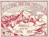
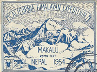
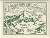
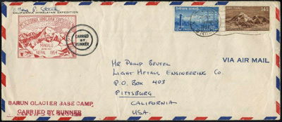
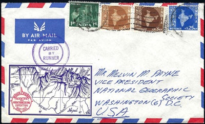
The 1954 California Himalayan Expedition The expedition left the U.S. with hopes of becoming the first to reach the summit of Makalu. This was the 1st attempt to scale the peak. The expedition objectives also included a full-fledged scientific program, including biological and physiological research. With tight funding, Dr. Swan, both a serious mountaineer and avid stamp collector, remembered the success of the 1924 Everest Expedition label. However, while several images of Mt. Everest were available, there were none that gave a clear view of Makalu. Dr. Swan finally found an image that captured Makalu from a photo of the Mt. Everest range taken during the 1933 Houston Mt. Everest Flight. Dr. Swan used the image and a little artistic license to create the expedition label. The expedition employed 3 markings that were applied in either black or red on the mail. The first was a double-double circle. The straight line BARUN GLACIER BASE CAMP marking was applied to mail processed at the expedition base camp post office. There was also a straight line CARRIED BY RUNNER marking that has only been identified on the general expedition mail. According
to Dr. Swan, the souvenir covers are considered a triple franked cover.
The labels were affixed to the envelopes at the “unofficial” Barun Glacier
P.O. used by the expedition members and porters. The label (an unofficial
local) paid for the mail to be carried from base camp by an expedition
porter to Biratnagar, Nepal where the Nepal stamps were added and cancelled.
Because Nepal was not part of the U.P.U., the mail still needed to reach
an Indian PO to continue to its final destination. The Nepal PO dispatched
the mail with another “official” runner across the border to Jogbani,
India for a posting on to it’s final destination. Thus a triple franked
cover! |
|
|
|
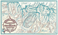
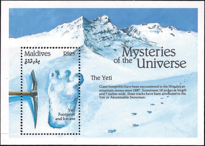
1960-61 Himalayan Scientific and Mountaineering Expedition In 1960, a 9-month scientific expedition was launched to the Makalu (8,481 m/27,825 ft) region under the leadership of Edmund Hillary. The expedition was formally named the “1960-61 Himalayan Scientific and Mountaineering Expedition.” However, it picked up a few unofficial names along the way. “The Silver Hut Expedition” based on the name of the upper hut at 18,000 feet. “The Hillary Expedition” and “The Yeti Expedition.” The main objective of the expedition was physiological and meteorological research. However, in order to get the 9-month commitment from mountaineers, a permit was secured for an attempt on Makalu. Another objective was the quest for the elusive yeti. Originally a request of the sponsors, 'World Book Encyclopedia’, the expedition embraced the idea as another way to keep the mountaineers active while they were not climbing. The expedition employed 2 labels. Both show a map of Nepal from Kathmandu to Everest and Makalu. Like the 1954 Makalu expedition, Dr. Swan also designed these labels. As mentioned earlier, to help market the expedition and keep members active, a search for the Yeti was implemented. The 2nd label includes relief shading and the shadow of a Yeti foot print. Keep in mind that at the time of this expedition, the idea of the Yeti was not a farfetched idea. In fact, during the 1951 British Mount Everest Reconnaissance Expedition, the team photographed what they believed to be a Yeti footprint in the snow. They laid an ice ax next to it for size comparison as depicted on a stamp from the Maldives. While the team did not reach the summit of Makalu, they were successful at the 1st ascent of Ama Dablam (6,812 m/22,349 ft). Considered one of the most beautiful peaks in Nepal, in 1960, no one had been successful at ascending it’s steep and imposing ramparts. From the silver hut and a month’s effort, 2 climbers reached the summit. |
|
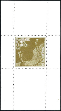
1970
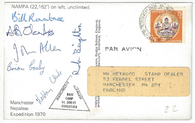
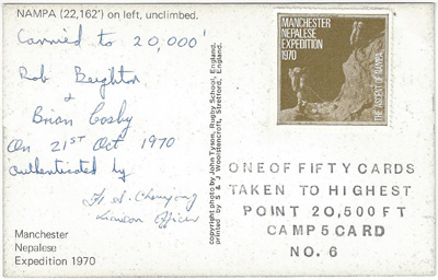
Manchester Nepalese Expedition In 1970 a group of 6 climbing friends hit the road as the Manchester Nepalese Expedition to climb Nampa. Nampa was an unclimbed peak, 6755 meters or 22,162 feet, in the far western edge of Nepal. They drove for over a month from Manchester, England to Pithoragarh India where they were able to hire porters and cross over into Nepal on foot. The team created a label in sheets of one for the 50 post cards that were planned to be carried to the summit and sold after the expedition return to England. The expedition employed 2 markings on the mail. The 1st was an oval marking with the expedition name that was used while enroute to base camp. Once at the base camp, the team used a triangular marking with the expedition name and "Base Camp 14,000 ft". The team created a label in sheets of one for the 50 post cards that would be carried to the summit and sold after the expedition return to England In
the end, the team made it to 20,000 feet. I’m not sure why there is a
discrepancy between the hand written altitude and the stamped altitude
on the card to the right. The cards with the expedition label were signed
by the climbers that carried the cards to the high point and authenticated
by the expedition liaison officer. |
|
|
|
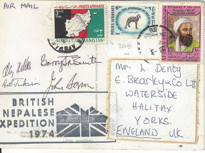
1974 British Nepalese Expedition A few years later in 1974, another 5 climbing friends headed out to climb Nampa South, another unclimbed peak at 6830 meters or 22,408 feet. They purchased a surplus army ambulance and on February 4th, 4 members hit the road headed to Kathmandu. The expedition employed 1 large marking with a vague expedition name considering there could be dozens of British expeditions in Nepal in 1974 and the Union Jack in the silhouette of mountains. The expedition mailed several cards along the way to include, Turkey, Afghanistan, India and finally, Nepal. What peak did the team attempt? It’s not completely clear. An expedition report states that the team planned on Nampa South and when they arrived in the region they were told by locals that the name is Rokapi. The problem with that is that Nampa South is not well documented in expedition reports of the time. There seems to be more confusion on the internet on which peak is Rokapi. Add to the confusion, the only peak in the area that seems to match the elevation of the peak the team attempted is called Jethi Bahurani. In the end regardless of which peak they attempted, the team was halted
by bad weather about a thousand feet from the summit.
|